On this day, the current topic is hydroelectric power! This post, inherent to the nature of the topic, will also tend towards the technical. One of my first official duties is to gather data, develop a project profile, raise funds, and install a 12 kW reverse water pump (giving water, getting electricity) in the local Quechua community of Llupa--all within a two-month timeline.
The purpose of this project is to replace our current 12 kW reverse water pump with a newly purchased 20kW water turbine (~$20,000) to satisfy our energy consumption at the lodge and the farmhouse 24/7. The original water pump would then be "loaned" to the community of Llupa to provide enough energy to power 12 to 15 houses (each taking between 0.5 and 1.0 kW). After an analysis of the power consumed by each household, the funds typically paid to the regional/national energy company and eventually funneled off-shore would then be paid into a community-managed central fund, which would then be doled out upon approval of a community-staffed committee to fund various community-development projects under the oversight of Ka'Way Monti NGO and The Way Inn Lodge, effectively keeping the money in the community.
My initial task was to map various waypoints along the stream, collecting GPS coordinates and altitude measurements. But before that could be completed, Alex guided me along the stream pointing out specific loci of interests. Passing adobe-style houses, we descended along the path that runs parallel to the stream. Several items of interest were being counted during this trek--number of houses with electrical boxes and number and locations of various stream diversions for example. We vaguely identified possible locations for the de-sanders and the water pump facility taking into account locations of houses, the relative amount of vertical drop, and the projected relative costs of pipeline vs. electrical wiring--all civil and electrical engineering aspects of the project. The technical feasibility of the project is just one of the four different elements necessary to generate a project profile to eventually present to potential fundraising entities. The financial feasibility, legal feasibility, and social/management feasibility of such a project must also be considered. But first things first...I had to gather pertinent data on the stream itself--the vertical drop/distance between various waypoints and the volume and velocity properties of the water flow.
Armed with Ryan's iPhone 5, I installed Altimeter, an application that promises +/- 5 meter accuracy in its altitude measurements, and set out along the stream. Stopping at various easily identifiable points of interest, I collected GPS and altitude measurements. The reliability of the collected data seemed to pass the personal "makes sense to me" test, with the exception of two particular regions through which altitude measurements oscillated +/- 20 m before equilibrating to a stable result. At the fourth crossing of the road that meanders back and forth across the stream, I concluded my descent. This was the site that Alex and I defined earlier as an idyllic location for our pump station. It was at branching point of the stream and relatively-speaking, according to eye-ball measurements, at a point of balance between the length of piping needed to extend from the de-sanders to the water pump to achieve suitable vertical drop (in order to generate the defined amount of energy to reach the maximum energy output of the machinery) and the length of electrical wiring needed to access the the electrical boxes of the maximum number of houses as determined by the maximum energy output. As the descent had concluded, I made good use of the trek home, by collected an additional set of geographic data throughout my ascent at each waypoint within 0.1' of the original GPS coordinates of each locus.
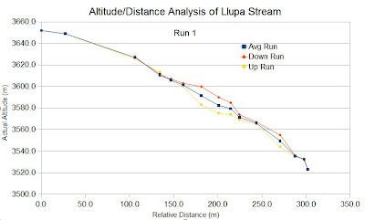
With initial data in hand, I calculated the distances (in meters) between each waypoint using a distance function derived from the Pythagorean Theorem, the culmulative distance relative to the point of origin, the relative altitude drop between each point, and finally the culmulative altitude drop at each point relative to the origin. Below is an altitude vs. distance graph of the results of the down run, up run, and average mean of the two runs.
Well, I guess that sums up my initial investigation into the feasibility of my first hydroelectric project. The technical data collection and subsequent analysis I feel will be the easiest aspect of this project for me. Financial analysis, fundraising, and social management of the project might prove more challenging, but then again, what's the fun without a challenge.
Until the next time... Be the change you want to see in the world around you.
Blessings,
Robert.

No comments:
Post a Comment